

Measuring the silt level in gully pots ensures an accurate picture is created of the gully network. This is done using a walked survey and dipping rods to show the silt level or by collecting the measurement prior to cleansing the gully.
Our Gully SMART software records these measurements to assess the risk of each individual gully and prepare an appropriate cleansing programme.
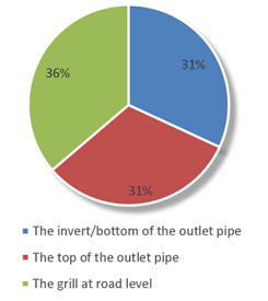
However, we have discovered that there are varying opinions on what ‘full’ means. When we ask the question, “What level in a gully is 100% full of silt?” we often receive differing opinions, despite the consistency of this measurement being so critical to any successful planning. Larger networks with more cleansing teams are more susceptible, as teams measuring silt in different ways contaminates the overall maintenance history.
What level in a gully is 100% full of silt?
Here at KaarbonTech, we have enhanced our software to allow a more accurate level to be recorded, and therefore a more efficient cleansing programme was created. This feature standardises silt measurement across all gullies, nationwide.
Issues with accuracy
An undefined measurement scale, best guesses, poor training and different subcontractors all influence the consistency of the measurement of silt in gullies.
There are many reasons that people feel the level of silt should be measured differently:
• Gully crews working via a subcontractor switch between multiple contracts, each with its own scale of measurement, causing confusion.
• Management of a measurement scale is not clearly defined so cleansing crews use their initiative to make an assessment
• Poor training of cleansing teams and their line managers
• Office staff movement from one contract to another. This can happen at most levels and many staff simply adopt measurement scales that they have used in the past rather than asking how things are done in their new role.
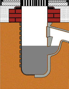
Relating silt measurements to invert (outlet) levels is also important, but so many networks have no accurate measurements of gully depth or invert level. Outlets can be at differing heights in the gully and when you add in the variety of differing gully pot depths across a network you can see how unreliable this data can be. When you factor for these variables, it’s no wonder that asking a gully cleaner to decide on a percentage full measurement brings inaccurate assumptions.
Additionally, local authorities relate silt measurements to outlet levels, but we have seen that many networks have no accurate measurements of gully depth or outlet level. Considering the differing depths of gully pots and the differing heights of outlets, measurement data is unreliable and a combination of all these factors means that a consistent, accurate approach, nationwide, is impossible.
A separate issue is noted when silt levels are historically recorded against quartiles as push button option, starting at 0%, moving to 25%, 50%, 75% and 100%. However, as most gullies have some silt, this has led to surveyors marking gullies at the minimum value of 25% full, even if they have less than this, to acknowledge the presence of some silt.
 How does the KaarbonTech silt slider work?
The Gully SMART silt slider feature displays a visual representation of the gully on the user’s tablet and allows them to move a slider up and down, drawing a realistic pictorial image of the silt level in the gully pot. The system converts this to a percentage of silt and rounds this up or down to the nearest quartile in line with agreed contractual settings. This gives a more accurate picture of the gully network.
For example, the silt slider will allow the surveyor to accurately record a pot as 10% full, but the result is rounded down to 0% for the means of risk scoring and work profiling. All the raw data is stored within the software so a much more granular level of reporting can be used in future based on historic inspections.
Benefits
The silt slider allows a clear, visual representation of the gully, giving the user the opportunity to precisely record the level of silt. This overcomes the education issue where one cleansing crew records the grill as 100% silt and another records the outlet as 100% silt.
Automatic rounding up or down allows Gully SMART to accurately risk-score each gully.
Cleansing programmes can be built using more accurate data, ensuring only gullies meeting certain criteria are cleaned, saving time and money.
Evidence
In KaarbonTech’s research, year-on-year surveys showed a decrease in the silt levels of some gullies previously measuring at 25%, due to realistic recording and rounding. More accurate results had a positive effect on risk modelling and resource management.
Accurate risk scores enable efficient programming
Using this information, along with location and vulnerability data, Gully SMART risk-scores each gully, creating a matrix showing the number of gullies that are similarly scored across the network. With a cycle length applied to each group of similarly-risked gullies, risk models can be easily compared and an appropriate cleansing programme created. Considering crews’ productivity as well as budget, local authorities can understand the number of cleanses achievable with the resources available. All this information is viewed on a map, allowing precise monitoring and planning, and reports can be run, extracting the information required and giving a clear, comprehensive overview.
If silt level is something used in your programming, then ensure you have the right education and software in place to allow you to collect accurate data.